22 July 2011

Karajini National Park 14/7 to 21/7


We were so looking forward to visiting Karajini, the second largest national park in Western Australia.  Not only had Jeff & Michelle Noonan told us a lot about it, but John & Kathie had also enjoyed their stay here. 

On the way from Tom Price, we had to pull right off the road so that two wide load vehicles could move on down the highway, the first was a brand new mining vehicle, probably worth a few million dollars. This occurred several times as we travelled these highways.  It seems that mining equipment is more often being moved down highways than in use in the actual mines.  We were also both keen to add an orange flag to our vehicle because it seems this is the preferred accessory in the area. 


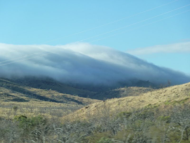
The thick cloud covering some of the Hammersley Range was quite an eerie sight as we neared Karajini.

On arrival at Dales Campground at Karajini, we were allocated a camping spot in the Dingo Loop.  There are over 140 campsites at Dales, all are located in circular loops.  There are plenty of clean toilets and centrally located gas barbecues, cooking rings and tables.  It’s an extremely well set up camp – great value at $10 a night. We spotted our first dingo on the drive into Karajini and we had been warned not to leave our shoes outside at night or they’ll be chewed by the morning.  It has been quite exciting to set up our campsite and know that we won’t be moving for seven days – a good break from travelling.
Termite Mound

Snappy Gum


When you first drive in, it is hard to believe in all this relatively flat country there is something spectacular hidden away.  That’s because instead of creating mountains, here the water has etched deep gorges in a landscape of spinifex and white snappy gums.  The landscape is dotted with huge termite mounds and there are also rock piles everywhere, some of which have been built by the local pebble mouse.  This landscape has taken more than two billion years to create and it has definitely left an imprint on our minds, with its ever-changing scenery of deep red rock, sheer cliffs and spinifex-clad rolling hills.
Threeways Dales Gorge
Dales Canyon (Can you see Donna?  Hint Pink Shirt)
We went to Dales Gorge first as it was the closest to our campground.  In Dales Gorge, apart from spectacular views of the craggy ochre-coloured rock faces, the highlights are Circular Pool, Fortescue Falls and Fern Pool.  We also walked the Gorge Rim Trail which offers stupendous views into the gorge.
Fern Pool

Mark & Donna in Fern Pool


From there we followed a steep descent into Dales Gorge where we were well rewarded with a swim at the tranquil swimming hole, Fern Pool.   
Fortescue Falls from the Gorge
Fortescue Falls from Rim of Gorge

Donna in Caitlyn Pose
 We also clambered down the rocks to the bottom of Fortescue Falls and enjoyed another swim at the bottom of this permanently  flowing waterfall.  The rockface down to the pool was usually crowded with people eager to have a swim or to watch others.
View into Circular Pool

Mark in Circular Pool - Do you think the water is cold?
On other days we returned and walked along the canyon floor to Circular Pool.  This pool is usually in shade and so the water temperature is not as comfortable as in Fortescue and Fern Pool.   
The fern-lined crystal clear pool, trickling waterfall and sheer rock face backdrop made Circular Pool sublimely beautiful.  With all this swimming we were hoping that the ochre-red colour would be removed from our feet – but definitely not yet!
Green Pool (Dales Canyon)

Blue Pool (Dales Canyon)
We've enjoyed returning to Dales Gorge many times over our week in Karajini and it has been a highlight of our trip so far. 
Canyon Face

The colours of the cliffs here are very difficult to describe.  There are so many layers of different colour that at times the cliff walls look like banded agate.  There are also layers of white and blue.  It was possible to see the fibres of asbestos in some of the blue layers probably because Karajini is not far from Wittenoon, which was an asbestos mine – closed because of the deaths occurring from the mining of this mineral.
Asbestos Fibres
We also travelled to the other gorges and enjoyed their spectacular scenery and quite challenging walks.  The view over the junction of the three gorges at Oxer Lookout was particularly breathtaking.
View from Oxer Junction

View into Hancock Gorge


However when we climbed down into Hancock Gorge and started wading through the water and spider walking along the sides of the cliff face our hearts were really thumping!
Hancock Gorge
Donna wading Hancock

Mark ready to Spider Walk


From there we moved on to Weano Gorge.  Parts of this gorge were spectacular especially when the gorge narrows and you’re wading through water with cliff faces a hundred metres high on either side of you.  Then you reach a section that can only be accessed by using a handrail and balancing your legs against the canyon walls while walking backwards as it’s too slippery and steep to go forwards.  Mark ventured this far, however I chickened out as someone had to keep the camera dry (or that was my excuse)
Weano Gorge
Weano Canyon (How did we get through?)

Mark Ready for Handrail Pool

Handrail Pool
In Kalamina Gorge we encountered our first snake in this area.  The olive pythons enjoy the water in Karajini and can grow to quite an impressive size.  I was glad we only met a baby.  Each gorge is different, but I have to admit our favourite was Dales and we enjoyed three days exploring and swimming in this gorge.
Snake in Kalamina Gorge

Small Waterfall in Kalamina Gorge

Donna trekking Kalamina Gorge

Kalamina Gorge


The road to the other gorges is due to be graded in two weeks time, just after the school holidays.  We think it is well overdue as we met three separate groups of people who suffered punctured (or shredded) tyres.  One of them lost two tyres on a Landcruiser and as they had driven from Tom Price to visit the gorges for the day, they had a 200 km round trip to try and get tyres repaired on a Sunday.  Luckily they were travelling with another friend and they used their vehicle to return to Tom Price.  It makes it a very expensive day out doesn’t it?
"The snake was this big!"
 We have been extremely fortunate in the weather while we’ve been at Karajini.  We’ve enjoyed clear blue skies and very warm days with the temperature reaching 29 degrees, the nights however have been very crisp – even used the hot water bottles a few nights! 
Karajini is a very special place and we hope everyone reading this blog gets a chance to see it one day!


13 July 2011

Carnarvon to Tom Price 8/7 to 13/7


Beach at Point Quobba
Campsite at Quobba
After leaving Carnarvon we headed to Point Quobba.  There is a bitumen road all the way to this coastal stop.  In this area are the Quobba Blowholes and Quobba Station which is a pretty dilapidated sheep station.  We decided to stay at the Blowholes Campsite rather than camp at Quobba Station.  The campsite at Point Quobba costs $5.50 a day all up, whereas the fees at Quobba Station were $22 for an unpowered site that would have been further away from the sea than our Point Quobba campsite.  Our other option at Quobba Station was to pay $25 for a powered site, however you aren’t permitted to use any plug in appliances on threat of eviction!  Luckily with our solar panels, power hasn’t been an issue for us throughout this trip.  The beaches at Point Quobba are much nicer than those at Quobba Station, so it was a no brainer for us today! 
Quobba Blowhole
We first ventured to the blowhole. When you arrive at the blowholes you are greeted by a large sign proclaiming “King Waves Kill” – a cautionary reminder that this picturesque coastline has claimed the lives of over thirty people in freak waves.  North of the blowhole there’s a cairn commemorating the loss of the HMAS Sydney in 1941.  It was also in this area that the survivors of the Kormoran came ashore.  The blowholes shoot water up to 20 metres in the air after being forced through holes in the coastal rock.
The landscape here is pretty amazing.  Out to sea there is a reef ensuring a protected snorkelling area in one little bay.  There is also a pretty wild surf beach.  Near the blowholes the coastal rock looks like a lunar landscape that drops to a wide ledge below that is a haven for birdlife.   On the roadway there is the limestone reminder that this whole area used to be a coral reef, with fossilised coral branches everywhere.
Ledge on Coastline

Coastline at Quobba


Barradale River Rest Stop
After leaving Quobba we headed northwards once again.  For those interested in fuel prices, diesel at the Manilya Bridge Roadhouse was $1.735.  We chose to stop for the night at Barradale River Rest Stop, which is a very large stop with very clean toilets and fireplaces.  Here we met a wonderful group of people.  Travelling in three caravans were two brothers and a sister and their partners.  Wonderful to see such a close family group with a great sense of humour.  We shared a campfire last night, exchanged some DVD’s and all decided to stay another night.  The river is a haven for local birdlife.  I enjoyed watching at least ten eagles in flight over the river.  To the east there is quite a lot of water however on the western side of the bridge there are only a few small waterholes, so hopefully they’ll receive rain here soon or the birdlife will have to move on.
East Side of Barradale Bridge

West Side of Barradale Bridge


We then started to head east towards Tom Price, stopping for the night at Beasley River Rest Stop.  The roads here have a lot of floodways, however even though there has been rain recently, most of these floodways are dry rivers.  Some however have water flowing beneath the dry riverbeds.
Beasley River
 Travelling through the Pilbara region has been wonderful.  The colours of this region have to be seen to be believed - deep reds of many different hues contrasted with the green of the shrubs and the straw colour of the spinifex which covers a lot of the countryside.  An interesting aside - spinifex is quite inedible - even camels will not eat it.  It also causes a lot of damage to animals that have to walk through it causing cuts and grazes on their legs.  The aborigines however found it very useful.  They made a dark bitumen-like glue known as 'kiti' that they used to secure blades to wooden tools - an ancient version of today's araldite!     Many wildflowers are also just starting to flower helping to make this drive one of the best so far!
Flowers Struggling Through Rock

Plants of Pilbara
Mt Nameless (Tom Price)

Spinifex in Pilbara

Pilbara Landscape
We arrived in Tom Price on a beautiful 29 degree day and spent the day preparing for our stay in Karajini National Park.  It was great to have telephone and internet reception once again as over the last 580 km there has been nil reception – roll on the Australia-wide broadband network. 

7 July 2011

Denham to Carnarvon 3/7 to 7/7

Beautiful Shark Bay - Denham
After enjoying our days in Denham we left to travel to one of the four freestays in this area.  We chose Whalebone Bay – a scenic spot right on the water.  Because the day started so wonderfully – blue skies and very calm water – we called in to Eagle Bluff once again.  Still no dugongs to be seen, however there was a pod of dolphins playing out to sea and wonderful views of the surrounding bays and over to Useless Loop.
Donna on boardwalk Eagle Bluff

Eagle Bluff


 Whalebone Bay was a great spot!  There were four caravans there for the night we stayed.  All had great views of the water.  Very quiet and once again not quite four star, at least four million star camping.
'Kat' the caravan at Whalebone Bay
Mark adding to cairn, Whalebone Bay

Whalebone Bay


From there we had planned to stop at Gladstone Beach however the road into this beach was closed due to the amount of rain the Gascoyne region had received the previous week.  It was with much trepidation that we set off along the dirt road into our next freestay – Bush Bay. There was water lying up to two feet deep along the side of this muddy track and with no space to turn around we were just hopeful that when we got to the intersection we would be able to head back to the highway if the road ahead was closed.  Luckily we were able to reach Bush Bay, even though the road to the other beach – New Beach was totally covered with water.  The number of caravans and fifth wheelers plonked at Bush Bay was amazing.  Most of these were ready to stay for months – already growing their own vegetables, firewood piled high, smokers ready to smoke their fish.  We were pretty amazed because compared to a lot of the places we had been it was quite ordinary.  After getting tips from the fishermen Donna was ready to go.....using worms she’d found among the wet seaweed in the mangroves......not a bite!  What we did notice about Bush Bay was the amount of wind.  It blew a gale for the two days we were there.
Carnarvon
 Our next stop was Carnarvon.  This town is right on the edge of the Coral Coast.  It is the only town in Australia where the central desert reaches out to the sea and once again the wind was blowing.  The last few days have been the coldest we have experienced – even though we’re further north than Kalbarri it has been much cooler.  It was quite evident when we drove into town that this wind is quite constant.  We took the HMAS Sydney Memorial Drive, which has an avenue of 645 palm trees and stone plaques – one for each sailor lost on the Sydney.  They were in a sorry state, many missing crowns the tops of which had been sheared off by the wind,  others were stunted or dead – a real shame!  But we came to realise that this should have forewarned us about Carnarvon itself.  For a town with six caravan parks, there was not much to see or do, apart from fishing.
Bananas in Carnarvon
 Carnarvon supplies 70% of WA’s winter vegetables and has 176 plantations which grow everything from bananas and mangoes to stone fruit.  How can it do this in such a dry area ?  The plantations are along the Gascoyne River.  Driving into Carnarvon from the south where there are few trees it is very reminiscent of the Nullarbor. 
Gascoyne River


 As you can see from the pictures of the Gascoyne, it can be a raging torrent in flood, but at present is quite shallow.  The sea near Carnarvon is shaded brown by the waters of the Gascoyne.  


OTC Dish
We drove to Carnarvon’s other highlights including the OTC (Overseas Telecommunications Dish).  This satellite dish was opened in 1966 and built with the help of NASA. Carnarvon was an active participant in the space race and telecommunications from here helped put man on the moon in 1969.  It was also from here that Australia received its first satellite television broadcast.  Now it is ‘closed for repairs’ as it has been since 1987.  


One Mil
On what is argueably the windiest day of our trip so far we ventured out to the One Mile Jetty.  This wooden jetty was built to help Carnarvon receive goods from ships.  It is located at the mouth of the Gascoyne River.  The last time that we can remember being this cold was sitting on the main ski-lift in Hotham during a blizzard, yet the temperature here today was 21degrees.....it felt that the wind chill must have dropped the temperature to almost zero!
Gascoyne River Mouth

One aspect that has really disappointed me about Carnarvon is that although it is not yet school holidays in Western Australia, everywhere we went there were school age children who were obviously absent from school.  Most were with adults!  There is a huge television promotion in this state using aboriginal football identities who are attempting to encourage parents to send their children to school.  By what we have seen in this town the campaign is definitely not working.  What the answer is, I don’t know, but it appears as though some parents have placed a low priority upon ensuring that their children and grandchildren attend their local schools on a regular basis.