3 Apr 2011

CAPE LE GRAND NATIONAL PARK 29/3 to 2/4

Driving from Kalgoorlie back down to the coast of Western Australia was interesting.  After we left Kalgoorlie the landscape was very similar....red dirt, coral gums, scrub and salt lakes....until we were about 100 km from Esperance.  Suddenly, even though there were still salt lakes, we had reached arable land.  This region, through the use of superphospates, has been able to grow grain.  Some small towns really make an effort to make travellers feel welcome. 

We had a rest stop at Scadden before we reached the turn off to Cape Le Grand National Park.  The facilities were not only clean, the murals on the outside were extremely well done.  There was also an informative display about the town and its history which was based on the farming and railway workers.

 I must admit the sign 40km before the entrance into the National Park....NO VACANCY – CARAVANS....worried us a little, but undaunted we decided to try our luck anyway.  Thank goodness Lucky Bay lived up to its name.  On our arrival there were two sites free and we set up the van and were warmly welcomed by John & Kathie who had arrived the day before.
Our campsite at Lucky Bay
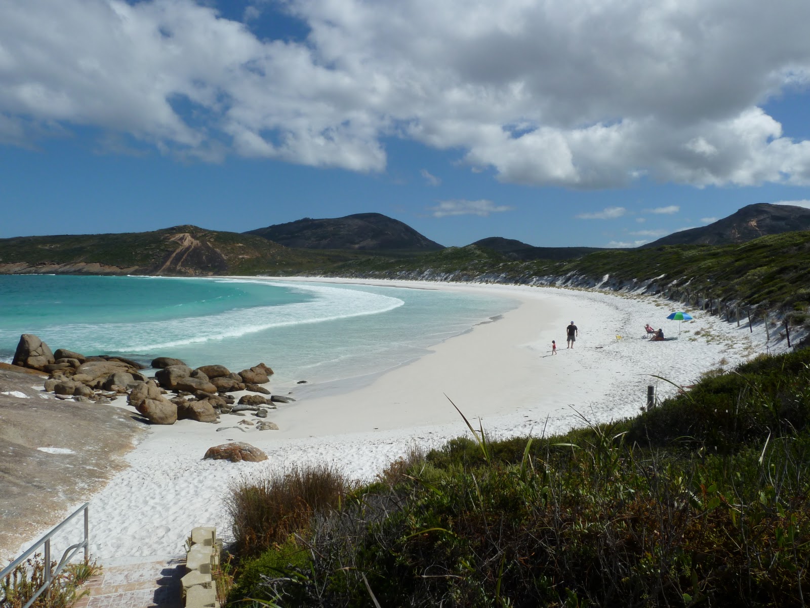
The sand at Lucky Bay is simply amazing!  As you can see from the attached photos it’s as white as can be and talcum powder soft.  I ventured in for a swim and the water temperature was wonderful.  (Much warmer than Pottsville kids!)  Mark and I also went for a quick walk over the rocks to a lookout.  We passed the Flinders Monument.  After travelling so far from Brisbane, you have to honour this sailor who circumnavigated Australia.  It was such a huge undertaking in his day.
The beautiful Lucky Bay

The View of Lucky Bay from the walk to Thistle Cove
Whistling Rock

More views on walk to Thistle Cove

Mark adding to the cairn
 On our second day in the park, we decided to walk from Lucky Bay to Thistle Cove.  It was supposed to be an ‘easy’ walk, but in parts we found it quite demanding.  Every corner we turned there was an amazing vista.  This part of the world is quite spectacular, the water is turquoise, emerald and sapphire blue, the sand is brilliant white.  We both swam at Thistle Cove and found when you leave the water and walk on the beach, the sand doesn’t stick to your feet like it does in Queensland, and nor was the water as salty.  However that may be because there is fresh water running into the sea at both Thistle Cove and Lucky Bay. 
Kangaroo posing for picture at Lucky Bay


 The wallabies and kangaroos in this region come down to the beach to drink.  Some even pose for photos!   
It was one of the nicest days of our trip so far.


If yesterday was ‘nice’ today, (Thursday) was spectacular.  Once again we awoke to blue skies and sunshine.  We decided today was the day to climb Frenchman Peak, so named because the rock atop the peak, looks like a beret.  It certainly was a climb, especially for me!!  However I knew that John and Kathie had climbed it the day before, so I wasn’t giving up.
Frenchman Peak

Mark at start of climb
Mark was very helpful, pointing out the easiest route from one marker to the next.  The view from the top was certainly worth the effort.  The ‘beret’ had a huge cavern with a fantastic view of this pristine area to the south.  Unfortunately, eventually we had to make our way back down        which was quite daunting at times.

Esther, a french visitor took this photo of us both in the cave at the top of Frenchman Peak

The view from the peak.

View of coastline from the cave

We then ventured to Hellfire Bay for morning tea. 
Hellfire Bay

 As we arrived, Cameron, the Head Ranger at Cape Le Grand said that there had been dolphins in the bay yesterday, and when we turned the corner, there they were again.  Once again, pristine blue ocean and chalky white sand...it certainly lives up to its reputation as one of the most beautiful beaches in the world.  Believe it or not, even after our 2 hour trek, we decided to head off to Little Hellfire Bay, which we had heard was the best place for snorkelling.  Well would you believe it, not only schools of various kinds of little fish; rock, coral and weed beds with larger fish moving in between; but also six dolphins who were swimming next to and underneath us. 
Hellfire Bay

Little Hellfire Bay

Donna snorkelling at Little Hellfire.  We were the only ones on the beach!
 It was extremely exhilarating and an experience we will always remember!  It’s hard to put into words what it’s like to swim with wild dolphin, who at times were less than a metre from us.  After the trek back to Hellfire Bay & lunch, we then enjoyed the surf at Hellfire Bay.  As we had come to expect, the water was so clear you could see the schools of larger fish in the waves forming close to you.  We hope to be able to repeat this experience tomorrow (except for the climb – as I feel that we’ve been there, done that!)

Unfortunately’ the weather on the Friday was overcast, cloudy and very windy; so we drove 120km to the Duke of Orleans Bay, where we ran into people who had also camped beside us at Lucky Bay.  We both agreed that the Duke wasn’t as breathtaking as Cape Le Grand, but we enjoyed the company and even went on a short 4WD track that led to a river.  (Hope the scratches in the cruiser will polish out!).  Then as the sun had returned we quickly headed back to Hellfire Bay for a swim.  At least, Mark swam; the rest of us found the water too cool today. 


Cape Le Grand Beach
On the Saturday morning we drove to Cape Le Grand Beach, from which you can drive along the compressed sand to Esperance.  Once again the pristine water and clean white sand was impressive.  There was a sailing regatta today from Esperance to Lucky Bay and it was interesting to watch the boats rounding the finishing buoy in gale force winds.
Regatta in Lucky Bay

John & Kathie collecting camping fees


Tomorrow we head for Esperance and leave John and Kathy at Lucky Bay Campground.  They have volunteered to be Camp Hosts at Lucky Bay and plan to stay in this wonderful place until at least Easter.  Their duties include collecting the fees for overnight stays ($9 per person).  Would you believe that there are websites explaining to people how to get out of paying the fees.  I think that the clean toilets, solar showers, wonderful walking tracks and AMAZING beaches are worth at the very least $9 a day. 

 
I hope everyone following this blog gets to see this part of Australia sometime.
Farewell Lucky Bay

28 Mar 2011

Kalgoorlie 25/3 to 28/3

We arrived in Kalgoorlie–Boulder as its is known, on Friday afternoon and our caravan park is located in Boulder. Upon our arrival, the first thing we noticed was that Boulder is dwarfed by the enormous ‘Super Pit – Gold Mine’ and most of the two story buildings in Boulder are propped up by large sections of scaffolding. 
Scaffolding in Boulder

 We have since learnt that Boulder experienced an earthquake last year and most of these two story dwellings suffered considerable damage.  However because these buildings have been heritage listed, we don’t think they will ever be renovated, due to the enormous costs involved.


Kalgoorlie Hotel
Kalgoorlie Hotel
Only a few kilometres away is the township of Kalgoorlie.  Kalgoorlie is dotted with very decorative buildings and displays a character of past grandeur.  In its heyday it would have been the place to be in the west and there wasn’t just a hotel on every corner; but all the way down the main street. 
Kalgoorlie Hotel
Butcher's Facade
 As you can see even the butcher shop had an elaborate facade.  Today Kalgoorlie’s population is very young, the average age is under 30 as they are here to earn good money from working in the mines.  The pubs therefore cater for the younger generation, most have karaoke, live music, and they actively market the existence of scantily clad young ladies known as “Skimpies” who are there to entice  the clientele.  Mark enjoyed a drink in the York Hotel.  It was full of interesting sporting memorabilia.  There was one of the Don’s signed bats, Mohamid Ali’s boxing glove, signed golf balls by Arnold Palmer, Tiger Woods & Jack Nicklaus....I could go on forever.  If you’re in Kalgoorlie call into the York to have a look around.

Mark & I also did the ‘Hay St’ (House o ill repute) tour.  The Madame was an extremely well spoken lady of at least 70+, who was originally from Brisbane.  It was interesting to see the ‘starting stalls’ where any keen man had to wait before being allowed to enter into the house.  They did look like horse stalls.  We could not recommend Kalgoorlie as a family friendly town, as we noted a lot of drunk people in the streets, even during daylight hours.  The worst we saw was a pretty blonde young girl of about 17 who was unable to walk a straight line at 4:30 in the afternoon.

Superpit View - The trucks look so tiny down there!

Kalgoorlie’s skyline is dominated by the ‘Superpit’.  Alan Bond was the entrepreneur who first tried to buy up all the separate gold leases on this ‘golden mile’.  This was completed by the company KCGM (Kalgoorlie Consolidated Gold Mining), who now employ thousands of people and have invested millions into infrastructure for this extensive mining operation.


  Before the superpit, the miners followed the seams of gold down as far as 1.2km underground.  Then it was realised that gold could be extracted from the ore that had been discarded.  They even pulled up the pavers in the city as they contained gold. Now a huge hole has been dug in the ground, with blasting occurring every day and hundreds of trucks removing ore.  According to the marketing blurb, the superpit is expected to last until 2021   At that time they will have to decide what to do with it, as the mine will most likely not be viable.
Up close the trucks are huge....

Once the mining is discontinued then the KCGM group will depart and a large hole will remain in the ground.  Once this happens the hole will fill with salt water and it will eventually fill the huge hole in the ground leaving a lake that will be toxic due to the leaching of arsenic etc.  The Superpit tour we did today was extremely interesting.  For example did you know that each of these trucks can hold 220 tonnes of ore (that’s 220,000kg). An average of 1 in 6 trucks carries ore that will contain gold bearing ore.  This ore will usually yield 2g of gold per tonne of ore.  However KCGM extracts about 200 000 ounces of gold each year making this ground still the richest mile of earth in the world.  Pretty amazing!


After searching through the Kalgoorlie cemetery for the great, grandparents grave (Yes Kelly, we found it) it was lovely to visit Hannan Park (named after Paddy Hannan who was the first to lodge a mining claim in Kalgoorlie) an oasis of green in the red dirt township of Kalgoorlie.  Not sure why it has a miniature Bavarian Castle, but at least there would have been enough stone in the local area for the project.


Michael & Ryan you might be interested in the bicycle we saw in the mining museum.  Don't know how it would go on your wind trainer.


From here we are planning to travel south to Esperance and we’ll be looking for a freestay in Cape Le Grand National Park or nearby Duke of Orleans Bay, however after wonderful weather across the Nullarbor and in Kalgoorlie we’ve just heard that rain and a cold front is forecast.


25 Mar 2011

Crossing the Nullarbor (21/3 to 25/3)


Day 1
We commenced our trip across the Nullarbor on a wet and windy Monday morning.  Our first stop was Penang Roadhouse for petrol and for John & Kathie another hole on the Nullarbor Links Golf Course. 
Mark & I stopped at the local museum where we not only learnt about the mouse, rabbit and snake plague in the district, but saw lots of household items that we remembered from our childhood.....IN A MUSEUM! 
The one thing that kept our attention was the high cost of diesel fuel.  We started off paying $1.56.9 in Ceduna and by the time we had arrived at the Nullarbor Roadhouse the cost of diesel had risen to $1.99.9 per litre.  Luckily fellow travellers had given us a warning about this and we did not have to fill our tanks at this stop.
A highlight of the day was our visit to Head of Bight.  After paying $5 each for the privilege, we enjoyed wonderful vistas of the Great Australian Bight.
Beautiful Colours of Great Australian Bight
Sand Dunes at Head of Bight


It was interesting that the sand dunes are marching inland at a rate of 12m a year.  At that rate they’ll be across the Eyre Highway quite soon.  Luckily we have encountered very little traffic.  A few ‘wide loads’ and some road trains but nothing to worry us.  
The Dann Clan might be interested in the road signs.  We’ve been watching out for Camels, Wombats and Kangaroos, but unfortunately none to be seen at present.  Jemma, we’re particularly on the lookout for wombats so we can put a star on our bingo sheets....but there are definitely no heart shaped clouds anywhere!


Day 1 Stop
We lucked out on our freestay for the night.  We’re in the Nullarbor National Park and can walk along the cliff face of the Great Australian Bight ....wonderful views, and as you can see from the photos we were lucky to have fine weather for most of the day.


 Day 2
We awoke to rain but by 9 o’clock had a fine, clear day.  We drove 80 km today, and also drove across airport tarmac.  Parts of the Eyre Highway are Royal Flying Doctor Service emergency landing strips. Our first stop was a scenic lookout that had been closed because the cliff had collapsed and the parking area now stood on the verge of joining the ocean.  We then went on to Bunda Cliffs Scenic Lookout, where the three layers of the cliffs jutting into the Great Australian Bight were very plain to see.  In a lot of areas there are signs that it is unsafe to venture further because of unstable cliffs due to undercutting caused by the sea.   We chose a stop close to the shoreline for our second night on the Nullarbor.  As can be seen from the photo we are sharing the free stay with loads of gravel and roadbase, which make excellent wind breaks.  Only 25km to the border.
Bunda Cliffs

Night 2 Stop


Day 3
Today we travelled ahead of John & Kathie who wanted to take a more leisurely trip across the Nullarbor.  Hopefully we’ll catch up with them in Kalgoorlie.  We had two stops before reaching the border.  On the first we went for a walk DOWN to the water. 
Mark on way down to water
Donna on way down

Our second stop was at a scenic lookout.  You can see that the cliffs have now given way to a more gentle slope to the sea.  Everywhere we stop we meet some fellow ‘terrorists’ as one Qlder called us tourists.  Today was a long day as we arrived at the border crossing at 11:45am   and left at 9:15am (Perth Time)

After the border was the ‘town’ of Eucla.  Once the site of the telegraph station that kept WA in touch with the rest of Australia and the world, now there is a caravan park, ambulance, police and aged care home.  After Eucla we went through a pass and for the rest of the day have travelled on the highway with plains to the south and a tableland to the north.  The land, though quite green because of recent rains, is no good for farming or grazing.  As per the signposts it is great for kangaroos, emus and camels.  People have tried to make this barren landscape more interesting by creating their own trees.  We passed a shoe tree, glove tree, undies tree, tinsel tree.  Took a photo of one tree that we need help with the theme.  There is a tv, shirt, cds....can anyone identify the theme?
Theme of tree????

Stopped for the night - day 3
We found a good spot for the night at Moodini Bluff in a grove of trees, which is very unusual in this landscape.  We were in bed quite early as the sun set around 6pm.

Day 4
After waking up quite early we set off on the next part of our journey. Our first stop was at Madura Pass Lookout, after we climbed to the top of the tableland.  The view of the Hampton Roe Plains stretched to the Great Australian Bight. 
View of Hampton Roe Plains

Second stop was Cocklebiddy Roadhouse.  After having to make sure we didn’t take any fresh fruit or veges into WA it was interesting to see brown bananas at Cocklebiddy selling at $1 each.  (That was the only fruit to be had).  The price of fuel here was $1.96.9 so once again we checked our tank & decided we’d be able to reach Norseman.  After the next stop, Caiguna, we encountered the longest straight stretch of road in the world.  90 miles, 146.6 km.  We stopped for the night at Woorlba Homestead Rest Area, after driving about 300km.  Luckily we have a shady spot, because it is very hot.

Day 5
We finished crossing the Nullarbor today.  We have been very lucky because we’ve encountered no headwinds or crosswinds, no rain, very little traffic and a great road surface.  Cannot even imagine what it would be like when it was a dirt road.  At the end of the Nullarbor is the town of Norseman. This mining town was established in 1860 after Laurie Sinclair’s horse, Norseman, as the legend says, pawed and exposed a chunk of gold reef. 
Statue of Norseman
View from Norseman Lookout of Mine & Salt Lake
Gold is still mined in the area today and between Norseman and Kalgoorlie (where we have set up for the night at a caravan park)  there are numerous mines. 
The streets of Norseman are extremely wide, being planned originally so that camel trains could turn easily in the street.  This is commemorated today by the corrugated iron camels in the main street. 
We were able to fill the car at the Shell Service Station where petrol was at a more reasonable price of $1.61.9.  (Thanks Ian Peacock for the tip)
 
So ends our journey across the Nullarbor.